Donate!

Wednesday, May 18, 2016

Woman Coats Shopping Guide

[I am an old Macy's employee, this information I am sharing we refer to as "product knowledge"]
 

FABRICATIONS
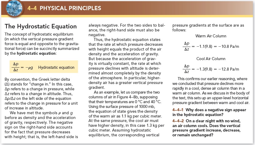
Wool—the most popular fabric used in coats; wool is a natural fiber that comes from sheep. It is warm, durable, retains its shape, repels moisture and resists stains.

Wool / Nylon / Silk Blends—adding nylon to wool makes the coat softer and more durable. Adding silk gives a rich sheen and elegant feel or “hand.”

Cashmere—comes from Kashmir goat. It is extremely soft and durable. It is lighter and warmer than wool, giving warmth without bulk.

Down—the light, fluffy material that exists between the duck (or goose) and its feathers. It is an excellent insulator, has great “breathability” and is water-resistant. Percentages on the labels of the coats refer to the percent of the fill in the garment that is down versus feather. Down itself is machine washable, but that doesn’t mean the shell of the coat is. Always check the label for cleaning instructions.

Leather—a generic term for all kinds of tanned animal skins. It is durable, wrinkle resistant and “breathes” to keep the customer comfortable. Genuine leather has markings and colorations which may appear to be imperfections but are actually part of the natural beauty leather offers. All leather must be professionally cleaned.


WARDROBING
            There are so many options you can use to build a coat sale. If the customer has warmth in mind, try suggesting a pair of matching gloves or hat. If she is looking for a polished look, suggest accessorizing with a cashmere scarf that will provide warmth without added bulk.


FAQ
What should I look for when buying a coat? What’s your ‘best’ coat?
            Buy a coat that fits you beautifully and is functional. A coat keeps you warm while making a fashion statement and is a staple of every woman’s wardrobe. Ladies’ coats are produced by a number of manufacturers and can vary in quality of workmanship. To determine quality, examine lining, hem, zippers and stitching.

How can I tell if the coat is the right size? Do certain vendors run small or large?
            Here are some tips to help find the right fit:
     Button all the closures on the coat and check for pulling across the bust, back and underarms. If there is tightness when you cross your arms and raise them above your head, you may want to get the next size up.
     Make sure the hem is even all the way around. A shorter hem in front could mean that the coat is too small across the chest, a shorter hem in back could mean that coat is too small across the back.
     If the coat has back or side vents, make sure they’re not separating.
     Make sure sleeves hit right below the wrist bone.

What should I consider when choosing a coat length?
            Here are some important considerations:
     If you’re frequently getting in and out of a car, choose a shorter coat for ease of movement.
     If you’re always getting on or off trains or buses, you’ll need a ¾ length coat (or shorter) that will provide warmth but that you don’t need to worry about constantly stepping on.
     If you walk a lot or live in extreme cold you’ll want a full length coat to shield you from the elements.

What style will flatter my body type?
            Here are some basic guidelines you can use to help find the best look:


Tuesday, May 17, 2016

Thermodynamic Diagrams (Skew-T Log-P)

The vertical measurements, or soundings, are taken when a weather balloons released with a rawinsonde—a light-weight instrument equipped with a radio transmitter that sends measured data back to a receiver on the earth. Whereas a radiosonde, often used synonymously, consists of the measuring devices rather than the rawindsonde, which refers to the addition of radio tracking capabilities to determine wind speeds and directions as well. Rawinsonde observations, or raobs, are taken twice daily at 00:00 and 12:00 UTC (Universal Time Clock) or equivalently, GMT (Greenwich Mean Time), 365 days per year. (For an excellent description of rawinsondes, see http://www.aos.wisc.edu/~hopkins/wx-inst/wxi-raob.htm).
Thermodynamic diagrams allow for analysis of temperature, moisture, pressure and wind in the atmosphere. By plotting the soundings of temperature and dew point, one can investigate how adiabatic processes determine instability and may be used to help predict severe weather—certain profiles indicate certain weather to be expected. The psuedo-adiabatic diagram at first looks very confusing. However, once we take apart the diagram and look at each line individually, we will determine the purpose of each line. When you get past the part of searching for the right line, the information is easily attainable.


Find Temperature (T)—lifted dry adiabatically—by starting at the initial point (given temperature and pressure) and travel upwards parallel to the nearest dry adiabat. When lifting the parcel wet adiabatically it is important to stay equidistant between two wet adiabats since the wet adiabats diverge with decreasing pressure. Do not go parallel to just one!

Find Mixing Ratio (w) by locating the value of the constant mixing ratio, w, line at the given pressure and dew point. Interpolate—approximate between the known values by the fractional distance between each one—if necessary.

Find Saturation Mixing Ratio (ws) by locating the value of the constant mixing ratio, w, line at the given pressure and temperature. Interpolate—approximate between the known values by the fractional distance between each one—if necessary.

Thickness of a Layer (ΔZ) is the vertical distance between two levels of constant pressure. In usage, it is the vertical distance between to isobaric surfaces. Since warm air is less dense than cold air (at the same atmospheric pressure), to travel through a layer of air that is warmer it will require a greater vertical distance to drop a given amount of pressure.


Find Lifting Condensation Level (LCL)—the level at which air, dynamically lifted, reaches saturation—by locating the intersection of the constant mixing ratio, w, line through the dry adiabat line.


Find Equivalent Potential Temperature (θe) by lifting a parcel dry adiabatically until it reaches the lifting condensation level (LCL) then lift it wet adiabatically until all the vapor is condensed out. The wet adiabat will be parallel to the dry adiabat, since all vapor is removed causing no latent heat to be released. When this occurs, follow a dry adiabat back to 1000 mb.

Find Convection Condensation Level (CCL)—the height at which a parcel of air, if heated sufficiently from below, will rise adiabatically until condensation begins—by locating the intersection of the constant mixing ratio (w) line through the surface dew-point temperature, TD (with the observed temperature sounding—as measured by a radiosonde). In the most common case this is the height of the base of cumulus clouds (which are produced by thermally-induced turbulent eddies—i.e. convection solely from surface heating).

Find Convective Temperature (Tc)—the surface temperature that must be reached to start the formation of convective clouds by solar heating of the surface layer—by locating the convection condensation level (CCL) and following it dry adiabat down to the surface pressure isobar.

Find the Level of Free Convection (LFC)—the level at which a lifted parcel of air becomes unstable (when the temperature of the parcel becomes warmer than the environmental temperature; Tparcel > Tenvironment)—by lifting the parcel dry adiabatically until you reach the LCL (lifting condensation level) then lifting it wet adiabatically thereafter. The LFC is the beginning of CAPE (convective available potential energy) / PBE (positive buoyant energy).


Find Equilibrium Level (EL)—the point of intersection where the temperature of the parcel becomes colder than the environmental temperature (Tparcel < Tenvironment = stable air). The EL indicates the end of CAPE (convective available potential energy).


 Find Potential Temperature (θ)—from the temperature, follow the dry adiabat to 1000 hPa. The isotherm value at this point is the potential temperature (the dry adiabat is an isotherm of constant potential temperature).


Find Equivalent Potential Temperature (θe)—from the LCL, follow a saturation adiabat up to a pressure where the saturation adiabat parallels the dry adiabat. Follow the dry adiabat down to 1000 hPa, the temperature at this level is the equivalent potential temperature.

Find Equivalent Temperature (Te)— from the LCL, follow a saturation adiabat up to a pressure where the saturation adiabat parallels the dry adiabat. Follow the dry adiabat down to 1000 hPa, then follow a dry adiabat back up to the original pressure. The isotherm at this point is the equivalent temperature.


Find Wet-Bulb Temperature (Tw)—from the LCL, proceed down a saturation adiabat to the original pressure level. The isotherm at this point is the wet-bulb temperature.


Find Wet-Bulb Potential Temperature (θw)—at a given pressure level, find the LCL (for that level), then proceed down a saturation adiabat to 1000 hPa. The temperature at this point is the wet-bulb potential temperature.


Convective Available Potential Energy (CAPE)—the region where the air will experience positive buoyant energy (PBE), which indicates instability.

Convective Inhibition (CIN)—the region where the air experiences negative buoyant energy (NBE), which indicates stability (resisting vertical movements).

Parcel Stops when NBE (above the EL) is equal to the PBE (between the LFC and EL).

Thermally Direct & Indirect Circulations

Thermally direct circulations are when warm air rises and cold air sinks, converting potential energy into kinetic energy by lowering the center of mass (i.e. Hadley and Polar cells).


Thermally indirect circulations are when cold air rises and warm air sinks, converting kinetic energy into potential energy by raising the center of mass (i.e. Ferrel cell).


Thermal Wind

            Thermal Wind is the vertical shear of the geostrophic wind cause by a horizontal temperature gradient—it “blows” parallel to the thickness contours, leaving low thickness to the left. The Thermal Wind Equation states that the vertically averaged shear of the geostrophic wind (within the layer between any two pressure surfaces) is related to the horizontal gradient of thickness of the layer, in the same manner in which geostrophic wind is related to geopotential height.
Expressed as a linear relationship between vertical wind shear of the geostrophic wind and the horizontal temperature gradient,
            In a barotropic atmosphere—where density is only a function of pressure—the slope of the isobaric surfaces are independent of temperature thus, the geostrophic wind doesn’t increase with height. In other words, there is a complete absence of the horizontal temperature (thickness) gradients such that on constant pressure surfaces. However, the slope of the isobaric surfaces and the speed of the geostrophic wind may vary from level to level due to those thickness variations.
            In an Equivalent Barotropic Atmosphere, isobars and isotherms, on a horizontal surface map, have the same shape.
            In a Baroclinic Atmosphere—where density is a function of both pressure and temperature—the height and thickness contours intersect such that the geostrophic wind exhibits a component normal to the isotherms (or thickness contours). In other words, the horizontal temperature gradients cause the thickness of the layers between isobaric surfaces to increase with higher temperatures. When multiple layers are stacked on each other the geostrophic wind and the slope of the isobaric surfaces increase with height.


Sea Breeze / Land Breeze Circulations

Sea/Lake Breeze Front is a boundary that is usually small and temporary but usually causes an abrupt drop in temperature as it passes (a distinct boundary between the cooler maritime air and the continental air it displaces). Whereas, just a sea/lake breeze is heating over the inland area which causes air to expand upward and diverge at higher altitudes. This creates a surface low-pressure area and the sea breeze flows inland from the sea.
Pressure starts out equal over the land and sea/lake but due to unequal surface heating. The land is warmer due to the ground absorbing heat faster than the sea/lake, resulting in the ground heating the air by conduction. The less dense, warmer air is rising and expanding thus increasing the upper-level pressure and creating divergence above while, decreasing the pressure over the land. Whereas, over the sea/lake, the cooler and denser air which has a relatively higher pressure resulting in low-level convergence due to the fact that air flows from high to low pressure (pressure gradient force).
The strength of the breeze depends on the strength of the land-sea temperature difference (gradient). Sea/lake breezes occur mid to late afternoon when the land-sea temperature difference (gradient) is greatest and tend to be more intense than land breezes. Although, thunderstorms may develop if atmospheric instability is enhanced by surface heating.

Land breezes, on the other hand, are a reverse circulations that tend to occur during the pre-dawn hours. At night, the land surface cools more rapidly than the sea thus becoming denser resulting in a higher surface pressure and an offshore flow.

Quasi-Geostrophic (Q-G) Omega Equation

            The Quasi-Geostrophic Approximation assumes, among other things, geostrophic and hydrostatic balance. Noting that advection is overshadowed by the geostrophic contribution, only allowing limited departures from the geostrophic balance, is reason it is not simply geostrophic and, instead, quasi-geostrophic. However, the advection of vorticity and thermal gradients usually disturb the geostrophic and hydrostatic balance, which is where the quasi-geostrophic equation could come in handy. To put it briefly, the Q-G equation, on a hypothetical vertical motion field, restores the geostrophic and hydrostatic balance accurately and instantaneously. In other words, the vertical motion could be considered a response to the disrupting factor of geostrophic advection on a system. Although, more importantly, this should be thought of as a hypothetical scenario due to the fact that there is no physical manifestation thus cannot be measured.
The Quasi-Geostrophic Omega Equation represents a method for diagnosing midlatitude, synoptic-scale vertical motions at a specific time. Neglecting diabatic processes, it implies that vertical motion can be calculated from a series of geopotential height analyses at different pressure levels—it is a diagnostic measure of vertical motion based on geopotential height.

For 3-D laplacian of omega, ω (vertical motion) it is important to remember that the sign of the term is proportional to the negative of ω. It is, also, common to assume the dominance of vertical motion is sinusoidal: approximately zero at both the surface and tropopause, and attaining a max/min value in the mid-troposphere hence, qualitatively, like a minus sign.
The vertical differential of geostrophic absolute vorticity advection term is proportional to the rate of increase of geostrophic absolute vorticity advection with increasing height. Overall, vorticity advection increasing with height forces synoptic-scale upward motion. However, vorticity advection at some pressure (mb) alone does not force the vertical motion, it is the change of vorticity advection with height that does.
The 3-D laplacian of thickness (thermal) advection relates to the laplacian of (horizontal) temperature advection to vertical motion, ω—which are greatest when the gradients of temperature advection are large. The dot product, within the brackets, is proportional to the negative of geostrophic advection of thickness.

Nonetheless, warm air advection also plays a role in the Q-G equation because it will increase the thickness of the layer, resulting in higher heights aloft compared to below. Which implies the formulation of anticyclonic vorticity aloft and cyclonic below. In the absence of vorticity advection there is divergence aloft and convergence below. Which, thanks to the vorticity equation, we know that in order to decrease vorticity there has to be negative vorticity advection or divergence.

Mass Continuity Equation

            The Continuity Equation, applied to the atmosphere, is simply a rendition of the principle of Conservation of Mass, stating that matter can neither be created nor destroyed. Yet implying that, again, for the atmosphere, the [constant] mass may be redistributed. However, air parcels expand and contract as they respond to pressure changes that may alter their volume in one of two ways: those that are associated with sounds waves and those which occur in association with hydrostatic pressure changes; granted that hydrostatic volume changes are only taken into account when the equation is expressed in (x, y, p) coordinates.

Absolute & Conditional Instability

Instability is a race to get cold between the parcel and the environment, and we want to environment to win. We could help the environment win by making the environment cool more slowly and / or make the parcel cool at a slower rate. The parcel method, for example, talks about the parcel being a hypothetical box that does not allow any transfer of heat in or out but, allows only adiabatic temperature changes.

The stability of the parcel is dependent on the parcel’s motion after a forced displacement. As the parcel undergoes adiabatic change, its temperature is compared to the surrounding environment to relate differences in density. If the parcel returns to its original position it is considered stable, whereas if the parcel continues moving away from its original position it is considered unstable. Moreover, if a parcel is displaced but remains at its new position it is considered neutral.

Due to the fact that density differences are affected by the differences between the adiabatic lapse rates and the environmental lapse rate, one may notice that absolute instability occurs when the environmental lapse rate (ГE) exceeds the dry adiabatic lapse rate (ГD) [i.e. ГE > ГD]. Whereas, absolute stability occurs when the environmental lapse rate (ГE) is less than the wet adiabatic lapse rate (ГW) [i.e. ГE < ГW]. However when the environmental lapse rate (ГE) falls between the wet adiabatic lapse rate (ГW) and the dry adiabatic lapse rate (ГD) [i.e. ГW < ГE < ГD] the atmosphere is considered conditionally unstable, as you can see from the picture below


On the other hand, especially with regard to the potential for severe storm development, another type of stability becomes important: potential instability. While, static stability (discussed above) considers what happens to a small parcel (box) of air when lifted or lowered while the surrounding air is kept in place, potential instability contemplates what happens when an entire layers of air are displaced upward [i.e. a mass of warm air displaced upward by the movement of a cold front].


The Hydrostatic Equation

Hydrostatic Equation:

Hydrostatic Balance is when the net upwards force is equal to the downward force, requiring that the balance of forces in the vertical…
The pressure at height, z, is equal to the weight of the air in the vertical column of unit cross-section lying about that level.

Hydrostatic Equilibrium is when vertical pressure gradient force and the force of gravity are normally of nearly equal value and operate in opposite directions when…
     Gravitational force = vertical pressure gradient force in magnitude à no vertical acceleration occurs
     Gravitational force > vertical pressure gradient force à downward motion
     Gravitational force < vertical pressure gradient force à updrafts can develop that are associated with powerful thunderstorms.


Gradient Winds

Gradient Wind (or flow) develops only in the absence of friction, when considering curved flow and flows perpendicular to the contours, for the same reason as in geostrophic flow. However, gradient wind is not truly geostrophic because it is constantly moving, thus undergoing an acceleration. Nonetheless, this time, in order for the air to follow parallel to the contours there must consider the effects of the centrifugal force as well as the pressure gradient force and the Coriolis force.

Subgeostrophic Flow is when V < Vg, air curves cyclonically (counter-clockwise), and the CF needs greater than in the geostrophic case in order to balance the PGF.


Supergeostrophic Flow is when V > Vg, air curves anti-cyclonically (clockwise), and the CF does not need to be as great as in the geostrophic case in order to balance the PGF.

Putting it all together…