Thermally indirect circulations are when cold air rises and warm air sinks,
converting kinetic energy into potential energy by raising the center of mass
(i.e. Ferrel cell).
"You have to speak up in order for someone to hear you...you have to speak out in order for someone to understand you....you can't run in the dark and be afraid of everything and everybody. You should always think for yourself and speak out."
Donate!
Showing posts with label circulation. Show all posts
Tuesday, May 17, 2016
Thermally Direct & Indirect Circulations
Thermally direct circulations
are when warm air rises and cold air sinks, converting potential energy into
kinetic energy by lowering the center of mass (i.e. Hadley and Polar cells).
Labels:
air,
circulation,
descending,
direct,
indirect,
meteorology,
rising,
thermally,
weather
Sea Breeze / Land Breeze Circulations
Sea/Lake Breeze Front is a boundary that is usually small and temporary but
usually causes an abrupt drop in temperature as it passes (a distinct boundary between
the cooler maritime air and the continental air it displaces). Whereas, just a sea/lake breeze is heating over the
inland area which causes air to expand upward and diverge at higher altitudes.
This creates a surface low-pressure area and the sea breeze flows inland from
the sea.
Pressure
starts out equal over the land and sea/lake but due to unequal surface heating.
The land is warmer due to the ground absorbing heat faster than the sea/lake,
resulting in the ground heating the air by conduction. The less dense, warmer
air is rising and expanding thus increasing the upper-level pressure and
creating divergence above while, decreasing the pressure over the land.
Whereas, over the sea/lake, the cooler and denser air which has a relatively
higher pressure resulting in low-level convergence due to the fact that air
flows from high to low pressure (pressure gradient force).
The
strength of the breeze depends on the strength of the land-sea temperature
difference (gradient). Sea/lake breezes occur mid to late afternoon when the
land-sea temperature difference (gradient) is greatest and tend to be more
intense than land breezes. Although, thunderstorms may develop if atmospheric
instability is enhanced by surface heating.
Land breezes, on the other hand, are a reverse circulations that tend
to occur during the pre-dawn hours. At night, the land surface cools more
rapidly than the sea thus becoming denser resulting in a higher surface
pressure and an offshore flow.
Labels:
breeze,
circulation,
convergence,
divergence,
gradient,
lake,
land,
meteorology,
pressure,
sea,
temperature,
weather
Thursday, March 24, 2016
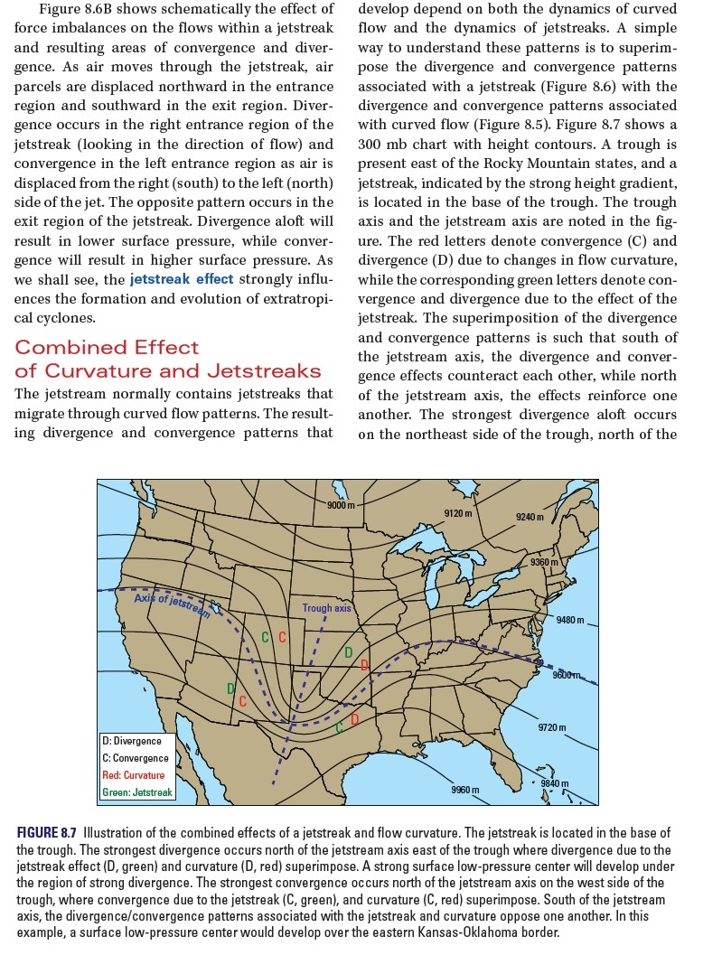
Jetstreaks and Associated Circulations
A jetstream is a narrow band of strong winds that encircles the Earth
in the mid-latitudes, containing regions where locally strong pressure
gradients produce exceptionally strong winds, called jetstreaks, which migrate through curved flow patterns. A jetstreak
is located in a region of strong pressure gradient and is indicated by the
large values of isotachs (lines of constant wind speeds) and the close spacing
of the pressure or height contours. As air moves through the jetstreak, air
parcels are displaced northward in the entrance region and southward in the
exit region. Divergence occurs in the right entrance region (looking in the
direction of the flow) while convergence in the left entrance region displaces
air from the right (south) to the left (north) side of the jet. Divergence
aloft will result in lower surface pressure, whereas convergence will result in
higher surface pressure.
Although the jetstream is not always
a single ribbon of fast-moving air encircling the pole. In nature, a single
jetstream can split into two branches and then merge again at a downstream
location. In fact, the most extreme low pressures associated with cyclones in
the middle latitudes usually occur when two (or even three) jetstreaks, each
embedded in a different branch, interact with one another as their parent
jetstreams merge.
Labels:
circulation,
climate,
convergence,
divergence,
jet,
jetstreak,
jetstream,
meteorology,
pressure,
streak,
stream,
weather
Friday, March 18, 2016
Physical Principles: Maintaining General Circulation
Understanding Weather and Climate (7th Edition) (MasteringMeteorology Series) by Edward Aguado, James E. Burt
Labels:
atmosphere,
atmospheric,
circulation,
climate,
engine,
exchange,
general,
global,
heat,
maintaining,
meteorology,
momentum,
motion,
physical,
principles,
weather
Subscribe to:
Posts (Atom)